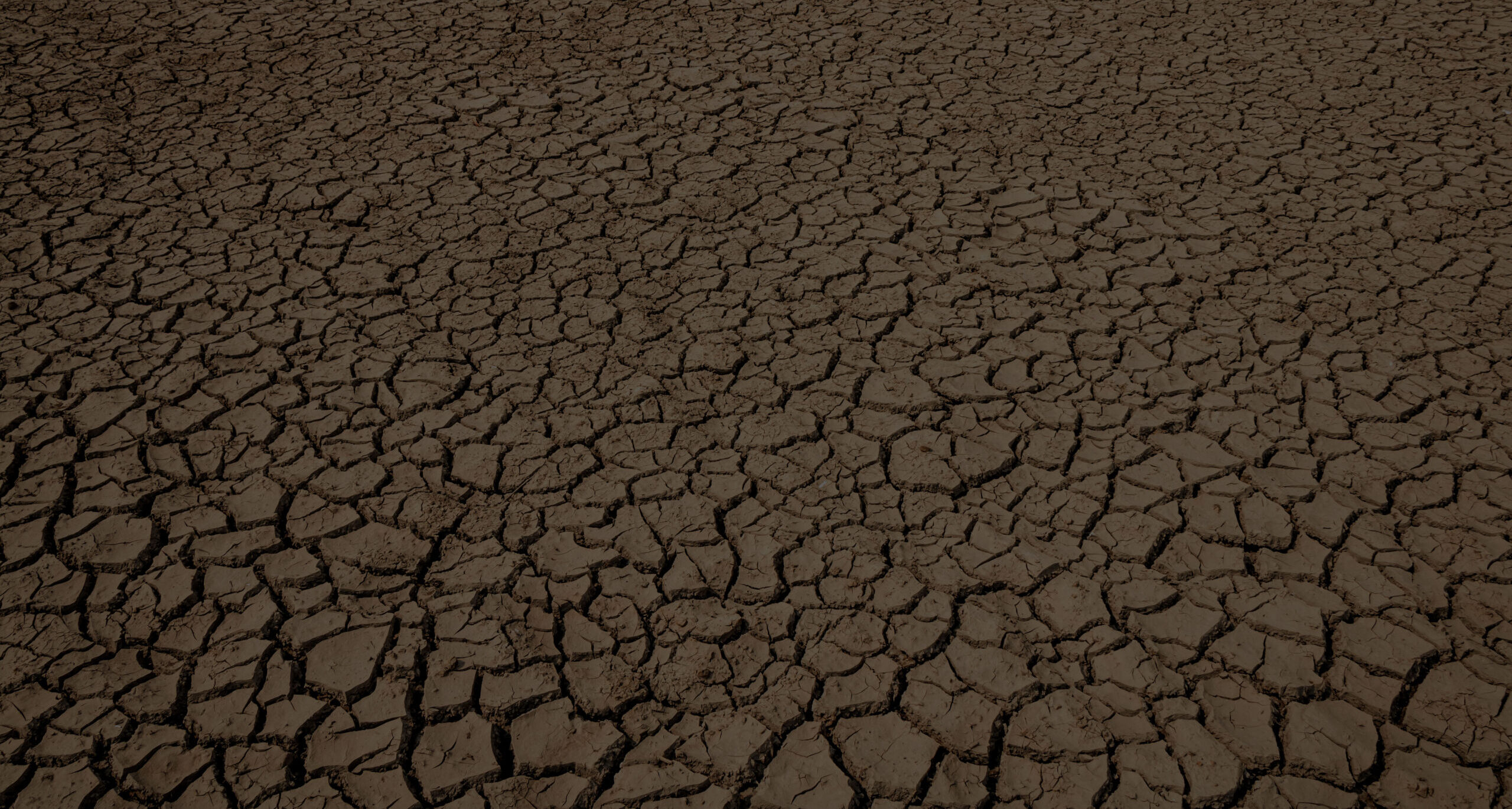
Dry, cracked dirt replaces mud in some areas due to abnormally dry conditions.
Missouri’s weather over the past three years has been just as arid as stretches of the Dust Bowl of the 1930s, setting up the 2020s to be perhaps the state’s driest decade in a generation. For farmers and ranchers, this outlook means finding innovative ways to manage increasing threats to their herds and harvests. The economic perils that result could further impact every family throughout Missouri.
Over the past half century the Missouri Department of Natural Resources has coordinated the state’s drought response. Within the agency, the circumstances of the 2020s drought have fueled one of the largest adaptations of this effort. These changes have been underpinned by the exploration of fresh opportunities and the goals of better gauging the state’s climate and more accurately guiding resources to where they are needed.
Last year, MoDNR’s Water Resources Center completed the first step of this innovation by releasing an updated drought plan outlining processes for better managing drought. This year, new technology is being deployed to expand the state’s monitoring capabilities. Once activated, this infrastructure will provide the foundation for even more advancements, reaching far beyond this drought or decade.
“The processes we’re beginning now will result in a true paradigm shift,” said Zack Becker, a unit chief with MoDNR’s Missouri Hydrology Information Center, or MoHIC. “Traditionally, when we’ve faced droughts or floods, we’ve relied on weather modeling that includes only so many weather stations. We also don’t fully respond with resources until those harsh conditions have already set in. When we achieve our goals with MoHIC, we’ll also know an area’s historical climate trends, giving us the chance to incorporate better data to accurately forecast where we need to help people prepare for floods or droughts before they develop.”
Drought’s different face
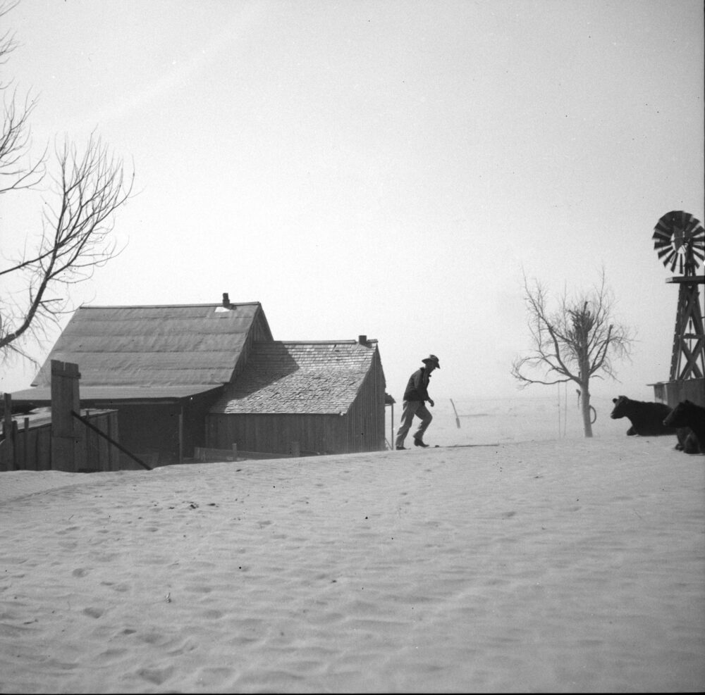
State climatologist Zack Leasor has fielded many questions about Missouri’s drought in recent months and the historic Dust Bowl has been a frequent topic. Leasor said the April-to-November stretch of 2023 was the seventh driest on record for Missouri since 1895, falling behind 1930 in rainfall and slightly worse than 1936.
“Of the years that have been drier are those that led to the Dust Bowl and other notable drought events, such as those in 1980 and 2012. We’re just as dry now as we were then for similar stretches of time, but we aren’t to the same duration in terms of experiencing as prolonged a drought and greater accumulated rainfall deficits,” said Leasor.
“MoHIC will let us all know with increasing accuracy what is happening with Missouri’s climate so we can better plan and prepare.”
– Zack Becker, Missouri Hydrology Information Center
Although Missouri has faced comparable dryness, scenes of the recent drought haven’t been as dramatic as the 1930s.
“The average person doesn’t realize just how much work has been done over many decades, protecting people from something like another Dust Bowl,” said Ken Henderson a division director with the Missouri Department of Agriculture. “They don’t see dust storms rolling across the plains, so assume everything is fine not realizing just how serious this drought has been. It’s taken a multigenerational push by the state and farmers going back to the 1930s to keep the worst from happening again by practicing effective soil and water conservation.”

Priming these efforts for success aren’t only management and funding, but the fact that there is community-level buy in. Every county in Missouri has a soil and water conservation district administered by members of those communities. Empowering local leadership with state resources has transformed soil and water conservation from a government goal to a central value in each community’s agricultural heritage
“When you talk to the board members of these soil and water conservation districts, you’ll hear them say things like, ‘My dad and my grandpa served on this board too,’” said Jim Plassmeyer, director of MoDNR’s Soil and Water Conservation Program. “Our success hasn’t just been as a program, but a mindset among farmers that we only have so much soil and so many acres we can farm, so we need to be protective of that resource as we pass it on to the next generation. Our cost-share program helps farmers achieve some of their conservation goals, but the ultimate success is due to their desire to protect their soils from eroding.”
While these practices have helped ward off another Dust Bowl, the recent drought brings with it what planners have begun referring to as “localized intensities.” These are the pastures that go from experiencing abnormally dry conditions to severe drought in as short as one month.
“The drought hasn’t been impacting the same locations across the state the same way all year and that’s made it difficult to map,” Leasor said. “It’d be a lot easier if we could look at the whole year and see the state’s been drying and wetting the same way. Instead, we’ve seen these pockets where some areas are improving while other areas are getting worse at the same time. It’s been very localized with conditions shifting around every few months.”
Mapping disparity
As the director for MoDNR’s Soil and Water Conservation Program, Plassmeyer each week compiles the number of active drought relief contracts across Missouri. Millions of dollars have gone into cover crops on row-crop acreage intended for livestock feed. However, not as much aid has been distributed to cattle ranchers. Even after the stunted spring 2023 hay harvest, opportunities like the program’s variances for grazing systems and pond cleanout didn’t have more participants among ranchers than average.
“Livestock producers have struggled during this drought and the way federal drought aid gets distributed can be frustrating for them,” Plassmeyer said. “I’m a farmer too and I understand it. I had to sell off 25% of my cattle herd to have enough feed to last through the winter. I farm in one county and I have family that farms in another county. The county I farm in qualified for federal assistance while their county did not. Seeing situations like that is what creates a lot of frustration among farmers when it comes to drought relief.”
Outreach by MoDNR’s Water Resources Center brought one clear answer to why this disparity exists: many ranchers felt the drought monitor map was not accurate. Jointly producing the drought monitor map each week are the National Drought Mitigation Center, National Oceanic and Atmospheric Administration and U. S. Department of Agriculture. Their decisions are based on readings from weather stations and computer modeling. How the map is drawn can determine everything from eligibility for emergency relief to insurance premiums.
“Livestock producers were reaching out with concerns about the drought monitor map and we would follow up with as many as we could to hear their feedback,” said Erin Fanning, program director of MoDNR’s Water Resources Center. “We were getting out there and trying to see with our own eyes what was going on across the state; not just in one community, but in multiple counties. We saw that there were places where it seemed the drought monitor was lagging behind. Based on our field observations, the conditions we saw were more reflective of other areas already characterized as experiencing severe drought.”
“Many USDA programs require NOAA weather gauges to set their requirements, but we don’t have a lot of NOAA gauges in Missouri,” said Chris Klenklen, deputy director of the Missouri Department of Agriculture. “I can understand why ranchers are upset when everybody’s hay insurance or pasture insurance is tied to the weather. You get in a specific 15-mile radius in these grids, but you’ve only got a handful of NOAA gauges across the whole state. They’re making a determination based on that gauge, but you may not live within 50 miles of it. The complaint I hear from cattle ranchers is, ‘Well, it didn’t rain on my farm, but it supposedly rained at the gauge, so I didn’t qualify for any assistance.’”
Some counties are completely absent data. Missouri’s streamgage coverage that measures the flow of creeks and rivers is limited to the existing USGS network. Other counties don’t have a single
soil-moisture sensor.
“Ultimately, we need data showing how much we’re drying out,” said state climatologist Leasor. “Soil moisture has been difficult to assess in Missouri. We really don’t have a lot of good soil moisture data from across the state.”
Data gaps like this can lead to adverse impacts for individual ranchers. The result can be not just a bad financial quarter, but loss of the community-level buy-in needed for a successful drought response.
“If the drought map is truly inaccurate, that could lead to delays in receiving financial assistance through government programs and possibly a complete lack of financial assistance,” Fanning said. “It takes eight weeks of severe drought to trigger certain forms of relief. If an area is experiencing those conditions and the drought monitor isn’t reflecting that, or even just lagging behind a few weeks, farmers could be greatly impacted but not see any financial relief if it then rains before that eight-week threshold.”
Smart almanac
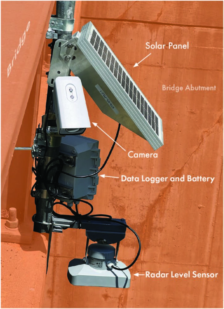
The Missouri Hydrology Information Center’s founding wasn’t in response to droughts, but floods. Following the 2019 deluge, Gov. Mike Parson formed the Flood Recovery Advisory Working Group. Among its recommendations were expanding the state’s weather gauges and sensors to create an effective monitoring network. Now known as MoHIC, this effort will be breaking ground soon on new infrastructure across Missouri.
“Our goal for MoHIC is to expand the number of streamgages and install more soil moisture monitoring stations,” said Becker. “These sites will each report ground-truth data, giving us a local look at what’s going on across the state when it comes to water, both above and below ground. Through MoHIC, we’ll also create a public-facing dashboard sharing all this information. Anyone will be able to log on and see how saturated the soil is in their area and how vulnerable they are to flooding if rain comes. As for drought, they’ll be able to see if only the surface is dried out or know whether drought conditions have penetrated to the lower soil levels.”
Becker said MoHIC is already designing its scientific inputs to enhance the accuracy of drought monitoring across the state.
“We’ve reached out to the individuals who make the drought monitor map and asked them directly what kind of data would be useful,” Becker said. “They gave us some examples and pointed to a site in Illinois that maps soil moisture and compares the results to that area’s historic highs and lows recorded over time. It helps them know what’s outside the bounds of normal and recognize when conditions, like a serious drought, have truly set in.”
Becker said the first of the soil moisture sensors will be installed in the near future to report readings as deep as 40 inches below ground. Streamgages are also being installed to show watershed saturation levels, floodwater crests and when drought dries out streambeds.
“Once we get started, our goal is to install additional sensors every week,” Becker said. “We want to keep going until we’ve filled all our data gaps.”
MoHIC’s data will be a welcome asset for Missouri farms. Just as the internet made the telephone a smart device we use each day, MoHIC’s dashboard of real-time readings and recorded historical trends will function as somewhat of a Farmer’s Almanac for the 21st century.
“None of us can control the weather, but each year MoHIC will let us all know with increasing accuracy what is happening with Missouri’s climate so we can better plan and prepare,” Becker said. “Good information helps you make the best decisions. Good information about soil and water conservation revolutionized how we began mitigating against drought after the Dust Bowl. My hope is what we learn through MoHIC will create just as positive an impact in how we respond to both flooding and droughts in the future.”
Beyond improving the drought map’s accuracy, the ultimate goal of MoHIC is to gain the confidence of Missouri’s farmers and ranchers.
“A key goal of ours is to win the trust of the agricultural sector when it comes to drought response,” said Elizabeth Kerby, MoDNR’s drought response coordinator. “Anytime we aren’t meeting that goal, we’re going to reassess and reflect on how we’re working. I really do think that’s one of the most important aspects of what we are trying to do, not only in the Water Resources Center, but at the Department of Natural Resources. We want to be transparent and allow people to see what we are seeing so they understand what is happening in the state. We especially want farmers to have the information and resources they need to prosper, even when facing drought.”
To learn more about drought in Missouri and view a current drought map, visit MoDNR’s Drought webpage.